.jpg)
Background
 By 2050, the Dutch government aims to reduce the country’s greenhouse gas emissions to zero and meet 100% of its energy needs via sustainable sources. One of the primary energy sources currently being considered to meet this lofty goal is geothermal, or energy derived from the Earth’s molten core. As a result, the government initiated a national seismic survey in conjunction with the Netherlands Organisation for Applied Science Research to map the country’s terrain and identify the best locations for future geothermal opportunities.
The project began last year with Rossingh Drilling being selected as the main contractor to carry out the project. The chosen GIS consultant is DavSeis, who selected Mango as their online GIS tool to help them manage and present spatial data to project stakeholders.
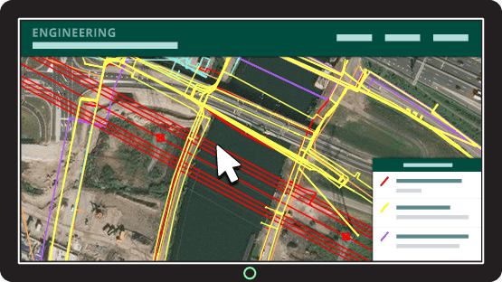
The Problem Mango Solved
The project encompassing tens of thousands of square miles of land mass and a team of more than 300 people, with 30 of those required to edit different types of geoinformation.
Data also needs to be shared with a variety of different departments, land owners, people in the field, plus many others.
Mango’s online functionality allows all 30 data editors to make instant, over-the-air edits to datasets out in the field via a tablet while enabling the remaining 270 stakeholders to access the latest, most up-to-date map whenever they want.
.jpg)
Sensors are placed to measure vibrations in the earth. Source: NOS
Making Mango the central repository of spatial data has streamlined workflows and enabled every stakeholder to access the maps they need in their latest iteration with the minimum amount of fuss, according to Vlad Cristian Nita from DavSeis.
“With an online tool like Mango, it’s easier to keep a track record of any changes. Everybody can then report to the GIS office and the GIS office can create maps. I provided each department with MoveeGIS/Mango and tablets so that people involved can easily access Mango and make updates online.”
Results
Alongside tools like GPSeismic and QGIS, Mango is successfully being utilized to ensure the seismic survey team have instant, up-to-date access to the project’s vital spatial data along with a central platform to deposit updates.
Team members can also take Mango out with them in the field via a tablet and make edits on the move, ensuring the project runs smooth and fast.
If you have a survey or seismic project and need an online GIS tool to help present, manage and share spatial data, get in touch with our team to discuss how Mango could help you.